Farragut Bay & Port Houghton Expedition
The Last Stands project is shared by Southeast Alaskans who are exploring rainforest threatened by massive public lands giveaways and reckless development. Collective adventure. Informed advocacy.

Bo and Marja have a homestead in Farragut Bay where they make a living running a small mixed vegetable farm. They have spent decades exploring the Farragut River valley and the mountains, lakes and forests that surround it. Most of their waking moments are spent trying to figure out how to grow bigger turnips but they also work to promote local commercial agriculture throughout Southeast Alaska. This is the story of their groundtruthing adventure through the lands near their farm. See photos of their farm, and hear from Bo here.
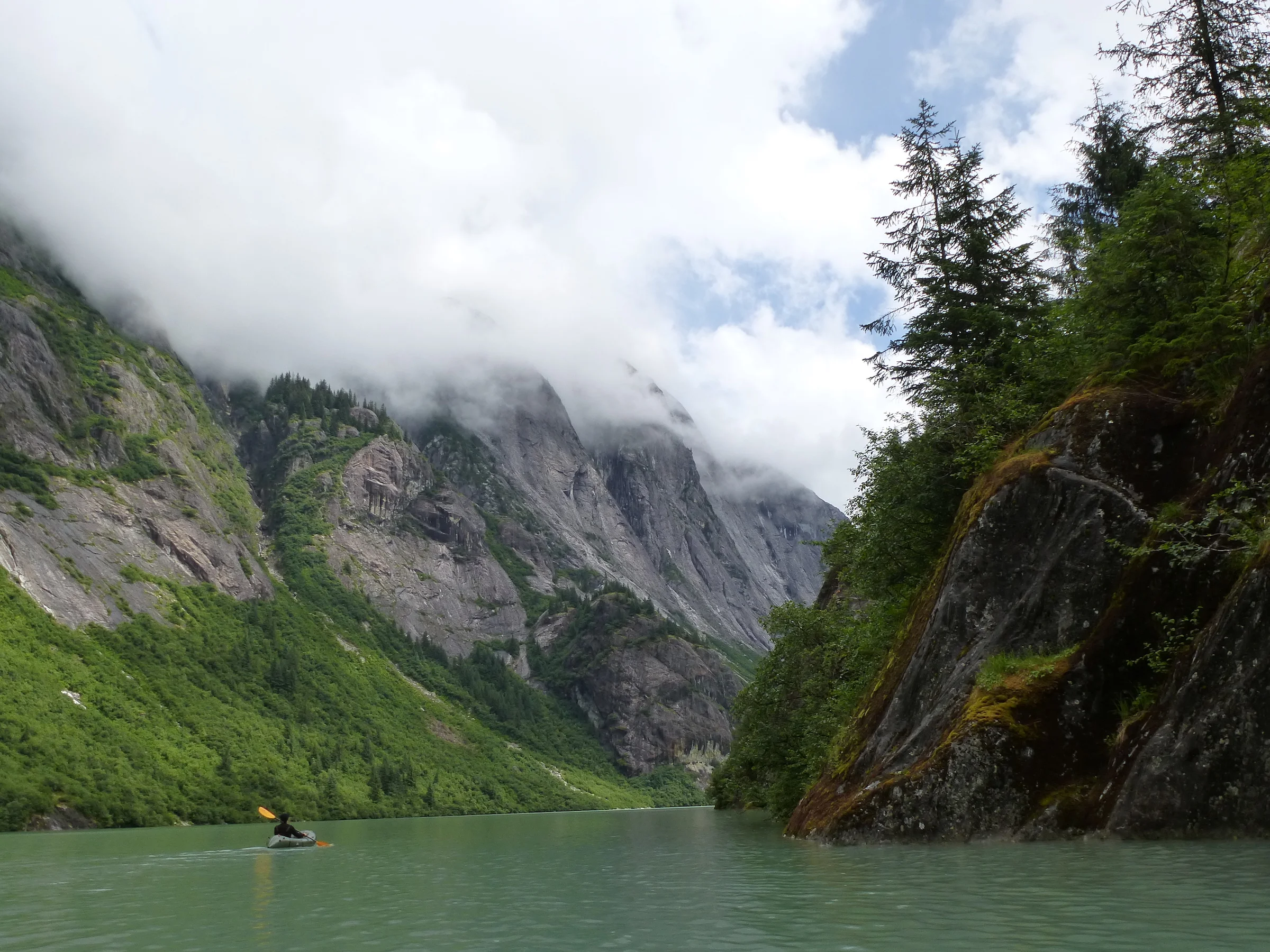
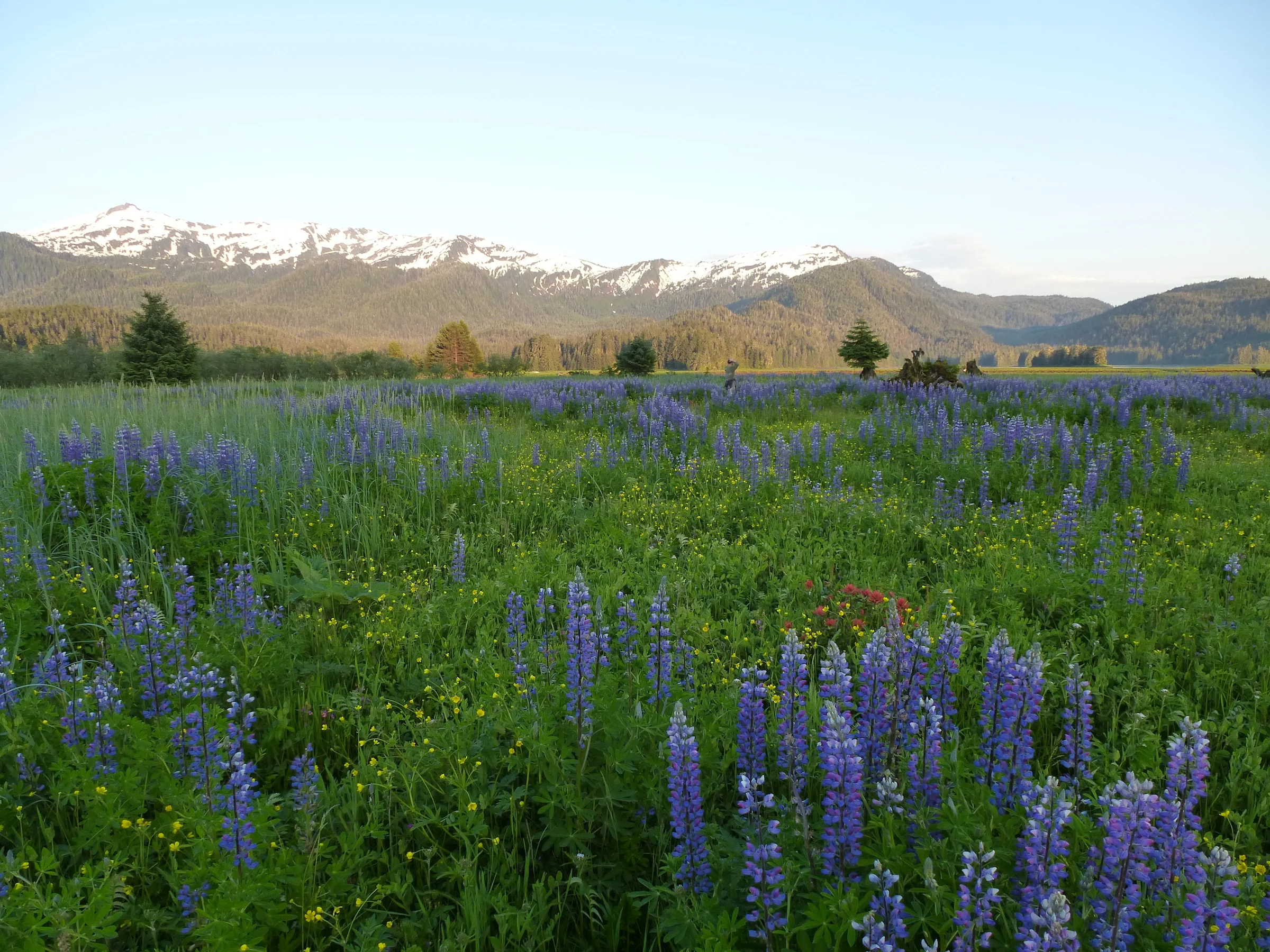
The Farragut river basin is wild to a degree that is exceedingly uncommon. Human impacts are almost nonexistent. There are no roads, there are no trails. This place remains as it has been for millennia. It’s an entire watershed that is completely intact. It’s also a stunningly beautiful place with flat valley bottoms flanked by snow-capped peaks. Where the river joins the ocean, dense forests give way to hundreds of acres of open meadowlands, filled with grasses and wild flowers. There are national parks and monuments less dramatic than this place. Including the Farragut river basin as part of a new state forest, formed with the express and prioritized purpose of logging every forested acre would be extremely shortsighted.
I have spent decades exploring the Farragut river basin and the peaks that surround it, but have never hiked from Farragut Bay over the hill to Port Houghton and the Sandborn canal. This area has also been earmarked to be part of the new state forest. Inspired by Elsa’s project to hike transects of all the HR 232 parcels on POW island and also by an uncommonly balmy stretch of weather in early August, Marja and I decided to hike our own HR 232 transect. So we stepped out our front door and began our transect!

The hike began with a tromp across the grassy meadows and soggy bogs of the Farragut river flats, land that is just inches above an extreme high tide. After wading through ¾ of a mile of head-high lady ferns and meadows burdened with grasses thick and heavy enough to depress (very slightly!) the continental plate, we arrived at the familiar moose trail that heads up the hill and goes to an old plane wreck. Some time in the 1970’s a twin engine prop plane on a commercial flight crashed straight into the side of the hill about 1000 vertical feet up from the flats. It’s a grim and sobering place even after 40 some years. A reminder of how suddenly vulnerable we are when our machines fail.
After the plane wreck, the way levels as the trail disappears and the brush gets denser! Fortunately we find a series of muskegs that link together a relatively clear path most of the way across to Sandborn...most but not ALL the way! At some point the option for speedy muskeg travel disappears, and we find ourselves perched on a broad ridge between two deep canyons with nowhere to go but down into the brushy, dark depths. Usually a Southeast creek is a terrible way to get from point A to point B -- downed trees, brush, devil's club, rocky cliffs, bears, walrus. Most Southeast creeks abound with every conceivable obstacle to foot travel, but not the creek we find ourselves traveling down! It is a clear path of scoured bedrock, the closest thing to a naturally formed gutter either of us has ever seen in Alaska.

We expect to run into a hundred foot cliff around every bend, but the way is open. What this creek lacks in diverse habitat it makes up for with easy traveling. We marvel at the sun speckled rock walls and the water falls just barely gradual enough to allow easy passage. Have we been transported to the Sierras? After a few miles of rock skipping the creek dumps us out on the shores of the Sandborn Canal and we camp for the night in sight of the lights from a luxury yacht anchored in the canal. Ahh, the juxtaposition of Southeast Alaska...so hard to navigate by land, so easy to get anywhere by water. Our campsite is in the flat, grassy meadows that surround the upper end of Sandborn Canal.
In the morning we follow the shore towards the terminus of the canal, until the tidal influence diminishes and we are skirting a freshwater creek on a significant bear trail. The creek meanders through the flat meadows forming large, deep, slow water pools. In the first few pools we are impressed by the schools of several hundred pink and chum salmon. The remains of Tlingit fish traps run diagonally across the stream, a whole series of traps with the sticks rotted off just above the stream bed but still very visible and intact. Further upstream the pools get wider, longer and deeper and now they are black with fish, many thousands in each pool. Neither of us has ever seen so many fish in such a small space; this stream is a huge salmon producer.

Soon the meadows give way to swamps where the creek exits the forest. The traveling suddenly gets much more difficult. We wade through mucky bogs until the mud oozes up towards the top of our boots. We head back to the stream and into a universe of brush. Every growing thing in this drainage is on steroids, fertilized by the salmon carcasses that lie half eaten everywhere across the forest floor. Devil’s club towers above us forming a dense canopy supported by needle clad pillars. Even though there are bear trails everywhere, the place is still such a dense thicket that we are crawling, ducking and vaulting over and under acres of prickliness. This is the densest brush either of us has encountered in Southeast.
The struggle up the creek continues past countless riffles and pools thick with spawning salmon. The trees that line the creek are huge. We would like to get closer to some of the bigger ones to get a better idea of their diameter, but it’s just too much work to thrash through the brush to their bases. Logs are down everywhere, criss-crossing the creek, making elevated bridges for the bears. And there are bears everywhere, gorging on salmon. This place is teeming with life.

This is not a very long creek. The portion that is suitable for salmon habitat is only a few miles, but the sheer quantity of fish using it is unbelievable. Every inch of those few miles is prime...if you are a spawning salmon. Not so much if you evolved on a savanna in Africa, but we manage to thrash our way all the way up to where the creek splits into several small, steep tributaries. We follow one that shoots straight up to the ridge that lies between us and our home in Farragut Bay. 2000’ vertical feet of steep hillside, following a godsend of a moose trail, and we are on top of the ridge surrounded by a swarm of horseflies that knows this might be the last day of the summer that’s warm enough for them to get out and suck someone’s blood. We set up the tent as quickly as possible and jump in, leaving our stinky socks outside draped over the bushes. The horseflies seem pretty happy to pursue the socks in our absence.
